

Headlines
- WARM AFTERNOONS & MORNINGS
- HUMIDITY REMAINS HIGH THROUGH MID-WEEK
- HEAT INDEX NEARS 100°
Indianapolis has done it. The capital city reached 90° for the first time in 2024. This will definitely not be the last time. In fact, this won't be the last time this month.
Temperatures are expected to reach 90° every day through Saturday. Even then, I am forecasting a high of 89° next Sunday. That means this is the first heat wave of 2024. (A heat wave is defined as three consecutive days reaching 90°.)
Along with warm afternoons we will not cool off much overnight. Lows are expected to only fall to the lower and middle 70°s. Oftentimes it is the lack of cooling overnight that will have a cumulative effect on people's bodies several days after a heat wave starts. Those with sensitivity to heat will want to be sure to stay hydrated through the week and find places to get out of the heat.

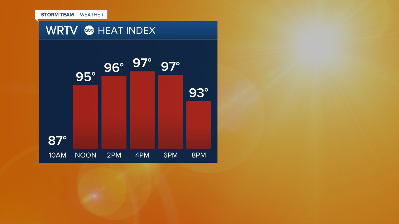
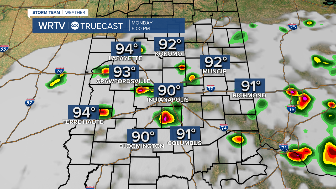
We start the work week with temperatures topping out in the lower 90°s. Factor in the humidity and heat indices will top out between 95° and 100° by late afternoon.
There will be enough moisture in the atmosphere to work with higher temperatures. This will lead to scattered showers and thunderstorms developing during the afternoon and evening. As of now, it looks like the chance for scattered thunderstorms to develop will occur once the temperature reaches 91°-92°. This should occur after 2 p.m. Monday.
Heat will be the national weather story this week. Temperatures will top out in the 90°s over the southwest U.S. , the Midwest, and even the east coast as an upper-level hot dome strengthens.
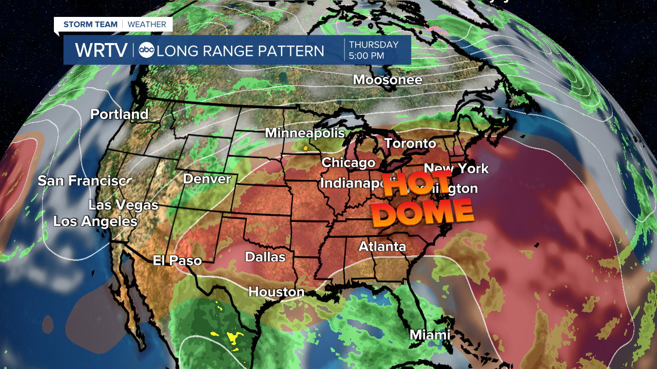
The upper-level hot dome will build to the west through midweek. As it does so, it will sweep away any chance for rain Wednesday and through the first half of the weekend. Long range computer models suggest the upper-level hot dome will break down, allowing a cold front to pass through the Ohio River Valley late in the weekend. If this holds true, the cold front will bring showers and thunderstorms to the state.
It is interesting to look at how this week could compare with the historical records. When looking at Indianapolis, if our forecast verifies, this would be the warmest June 16-22 in 153 years of records. Our forecast average temperature is 82.5°. The standing record is from 1994.
1. 1994 - 82.3°
2. 1888 - 81.4°
3. 1873 - 80.9°
4. 1954 - 80.4°
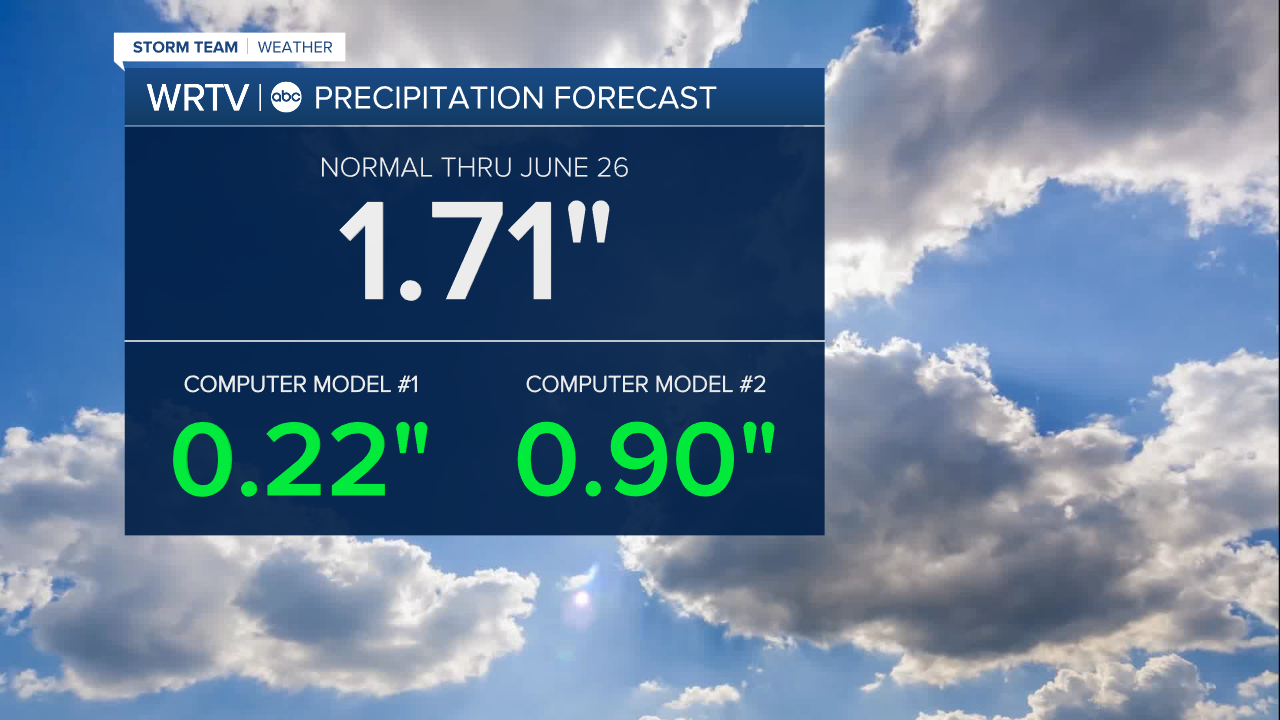
Rain is needed as the state is beginning to dry out. Right now, the soil is losing 0.29" of moisture from the ground every day due to evapotranspiration. That is nearly 0.10" higher than typical for this time of year. Hoosier soils are expected to lose nearly 1.75" of moisture through the upcoming week.
Computer models are bearish on organized rain over the next 10 days, suggesting just 33% the normal rainfall through June 25.
Indianapolis Weather Forecast:
Monday: Partly cloudy. Scattered PM t'storm. Peak heat index: 98° High: 93°
Tuesday: Partly cloudy. Isolated shower/t'storm possible. Peak heat index: 95° High: 91°
Wednesday: Partly cloudy. Peak heat index: 96° High: 93°
Indianapolis 7-Day Weather Forecast

